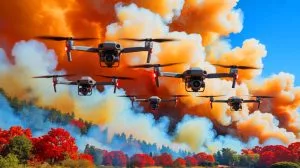
IN A NUTSHELL 🔥 Researchers have developed AI-powered aerial robots to track and map wildfire smoke in real-time. 🚁 These drones collect high-resolution data, improving atmospheric simulations and hazard response strategies. 🌍 The technology has potential applications beyond wildfires, including monitoring sandstorms and volcanic eruptions. 🔬 By integrating robotics and environmental science, the system offers … Continue reading “AI Drones Fly Into Wildfire Smoke”: Minnesota Scientists Create Robot Swarm That Maps Toxic Plumes In Real Time While Tracking Particles That Travel Hundreds Of Miles
10 Comments